
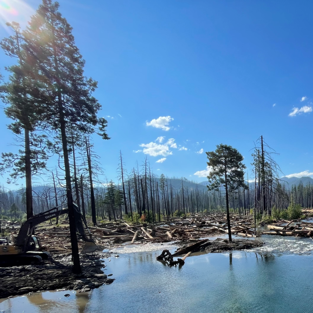
This summer, another stretch of the McKenzie River gained more room to move freely.
Watershed partners recently completed a major floodplain restoration project on the Lower South Fork McKenzie River, reconnecting more than 335 acres of historic floodplain and restoring approximately 1.8 miles of river upstream of Blue River, Oregon. Completed ahead of schedule and before salmon spawning season begins in September, the work gives the river more places to spread out and slow down—and more opportunity to create the complex habitat native fish and wildlife need.
The Lower South Fork McKenzie River Valley Reconnection Project – Phase 3 was led by the USDA Forest Service and McKenzie Watershed Council, and supported by the Eugene Water & Electric Board (EWEB) and McKenzie River Trust. It builds on more than a decade of collaborative restoration in the McKenzie basin and connects with work happening both upstream and downstream.
Together, these projects are helping restore a river system, one floodplain at a time.
Giving the River Room to Work
Historically, the South Fork McKenzie moved through a broad, dynamic floodplain, creating side channels, wetlands, pools, and other niche habitats important to spring Chinook salmon, bull trout, Pacific lamprey, and many other native plants and animals.
Over time, land use, flood-control activities, and the effects of Cougar Dam separated the river from much of that floodplain. Water became concentrated in a faster-moving channel, reducing habitat complexity and hindering the valley’s ability to naturally slow and store water during high flows.
The Phase 3 project helps reverse those changes using an approach known as Stage 0 Floodplain Restoration.
Crews used heavy equipment to remove and redistribute soils, place large wood throughout the valley, and reconnect dormant side channels. Instead of constructing new channels and asking the river to stay there, the work restores the conditions that allow water to weave across the valley floor.
From there, the river can do much of the work itself—moving wood and sediment, creating and changing channels, storing water, and building new habitat over time.
“This work is about restoring the river’s ability to take care of itself,” explained Lara Colley, Floodplain Restoration Projects Manager with the McKenzie Watershed Council. “We’re working with natural processes to rebuild habitat and improve conditions for fish and wildlife over the long term.”
Benefits That Travel Downstream
What happens on the South Fork matters far beyond the project boundary.
The McKenzie River is the sole source of drinking water for approximately 200,000 people in the Eugene area.
Reconnecting floodplains can help protect that resource by slowing water during high flows, allowing sediment to settle on the riverbed and water to soak into the ground and recharge groundwater.
That slowing and spreading is particularly important during storms, when sediment churned up by high water is the greatest contributor of turbidity and associated contaminants to the McKenzie River.
More space for water also means more options during extremes. A connected floodplain can store and slowly release water, while diverse, wet habitats can help the river system respond to floods, wildfire, and other climate-related impacts. At the same time, the returning network of channels, wood, pools, and slower water provides more varied habitat for sensitive fish and other wildlife.
Connecting Restoration Across the McKenzie
The Lower South Fork project is just the latest step in more than a decade of restoration efforts in the middle McKenzie watershed. Downstream and upstream, hundreds of acres have been restored since initial efforts on Deer Creek in 2016. Across the landscape, the McKenzie and its tributaries are gaining more room to move, and that movement nurtures a range of natural processes that create healthy river habitat.
These places are not isolated projects. Water, wood, sediment, fish, and wildlife move through the watershed without regard for property lines or project boundaries. Work upstream influences conditions downstream, and each restored floodplain adds another reconnected landscape, contributing to a more resilient river system.
That landscape-scale approach is possible thanks to partnership. Since 2015, the USDA Forest Service and McKenzie Watershed Council have been working to advance restoration in the middle McKenzie, and over time, the network of collaborators has continued to grow. The Lower South Fork project was also supported through federal, state, and local investments, including funding from NOAA, the Oregon Watershed Enhancement Board, and the USDA Forest Service.
“The scale of this work reflects the strength of our partnerships,” shared Darren Cross, McKenzie River District Ranger. “By working together, we’re able to restore entire river systems in ways that wouldn’t be possible individually.”
That same spirit of partnership runs throughout the McKenzie basin. Each organization brings different expertise, resources, and relationships. Together, those contributions make it possible to work at the scale of the river itself.
With Phase 3 complete, more than 335 acres of the South Fork floodplain are once again connected to the river. The landscape will continue to change as water returns to side channels, interacts with newly placed wood, moves sediment, and creates new habitat.
That change is the point.
A healthy river isn’t a river held in place. It is a river with room to respond, adjust, and create. From the South Fork to Finn Rock Reach and Quartz Creek, restoring the river’s ability to choose is helping prepare the McKenzie for uncertain changes ahead, all while contributing to better habitat, cleaner water, and a more resilient watershed for fish, wildlife, and communities.